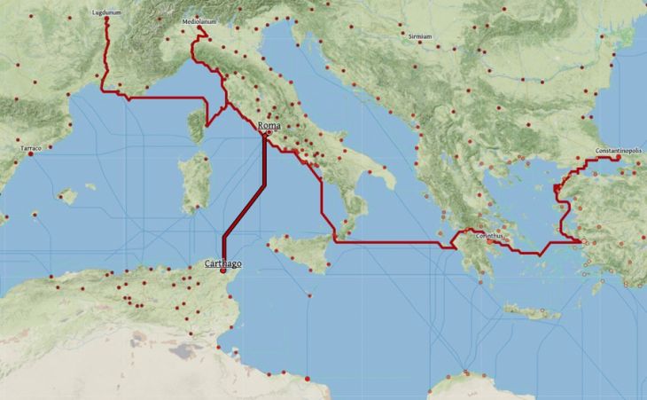
According to the “Google Maps of Antiquity” developed by Stanford University, Carthage was, by the means of the time, closer to Rome than any major European city.
How long did it take to travel from Rome to Carthage during the Roman Empire? Answer: 4.3 days (in summer).
For the time, this is very fast. Indeed, to go to Milan from Rome, it took 10.8 days!
It took 16.7 days for Rome-Lyon and… 27.1 days for Rome-London.
These travel times can be easily found on this interactive map designed by Stanford University.
(Just click on the map, then on the desired cities by choosing “Route to here” or “Route from here”, and finally on “Calculate route”).
The crossing was almost a direct line, and travelling by boat was much easier than travelling by road in those days.
And cheaper, too. The map also gives the cost of the journey for passengers and goods.
For example, for Rome-Carthage, one paid only 122.13 “denarii” per passenger (the “denarius” being the Roman currency; a word which gave rise to the Arabic dinar).
But for Rome-Milan, 378.85 denarii had to be paid. For Rome-Constantinople, 606.24 denarii. For Rome-London, the trip was ruinous: 900.93 denarii!
Thus, within the Roman Empire, Carthage was the closest of the great provincial cities. Almost a suburb of Rome…
But a few centuries earlier, it was the opposite. The small city of Rome was not yet the head of an empire, and the flamboyant Carthage dominated it by its prosperity and its technological advance.
The old Roman senator Cato, in the aftermath of Hannibal’s defeat, had good reason to warn his fellow citizens of the danger of such a close enemy.
By holding up a fig, picked in Carthage a few days earlier and still fresh, he managed to convince the Senate that Carthage had to be destroyed. As he tirelessly repeated: “Carthago delenda est!”
More about Tunis and the Coasts of Carthage.